Tsunami on the plains: USask researchers find sea waves once swept Prairie Provinces
Department of Geological Sciences researchers have found the strongest-ever evidence of a tsunami in a shallow inland sea
By Chris Putnam
Hundreds of millions of years ago, an earthquake sent a series of massive waves across the ancient sea that covered part of Western Canada and the northern United States.
That is the conclusion of a new paper by two University of Saskatchewan (USask) researchers who have found the strongest-ever evidence of a tsunami in a shallow inland sea.
The research by Dr. Brian Pratt (PhD) and Dr. Colin Sproat (PhD) of USask’s College of Arts and Science is published in the November 2023 issue of Sedimentary Geology.
Saskatchewan and its neighbouring areas are not known for their coastal views—or for their seismic activity. But 445 million years ago, in the period called the Ordovician, the region looked very different. Much of what is now Saskatchewan, Manitoba, Montana, and the Dakotas was covered by a sea known as the Williston Basin.
“It was a completely different environment, completely different geography. Back then, we were much closer to the equator than we are today and the sea level was high, so we would have been in a tropical, shallow inland sea rather than a temperate grassland like today,” said Sproat, an assistant professor in the USask Department of Geological Sciences.
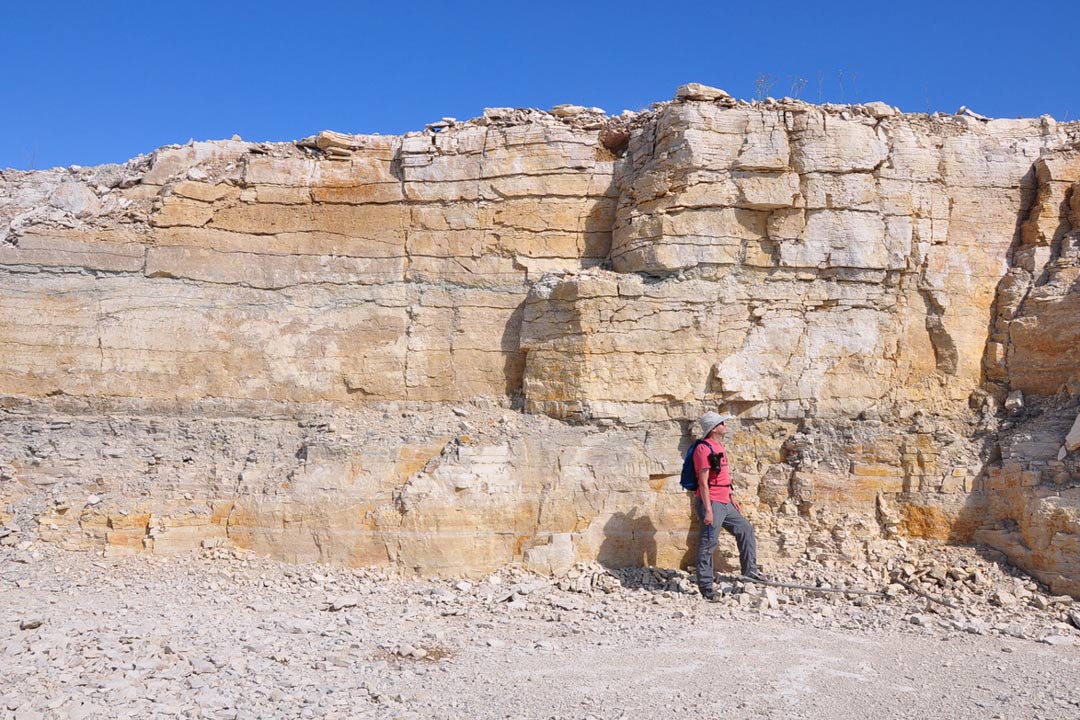
Pratt and Sproat visited three sites north of The Pas, Man., where they found evidence of a short, high-energy event in this ancient sea that had gone unnoticed by geologists until now.
Certain beds of sediment at the locations had been torn into pebbles and mixed with clay. The floor beneath the deeper waters of the basin contained no clay, so it could only have come from the land.
“We realized we needed an event that rips up the sea bottom and then somehow comes back again with all this clay, and does it a few times,” said Pratt, a professor in the Department of Geological Sciences.
The answer could only be a tsunami.

No animal life and almost no plant life existed on land to witness that day nearly half a billion years ago, but if an observer had been around, they would have seen a dramatic event.
Faults in the region’s crust, quiet now for thousands of millennia, were then still active. One of these faults somewhere in the northern half of the Williston Basin suddenly slipped, sending violent shockwaves through the sea.
The water at the shore would have briefly dropped, then rushed back in a relentless surge. The wave might have pushed a kilometre or more across the gently sloping land, scouring the rocky surface. When it finally receded, it washed clay back into the sea. More waves followed.
A tsunami is a “radical interpretation” of the evidence, acknowledges Pratt, but the USask researchers had an advantage. The strata of the Williston Basin in Canada are almost entirely hidden under Manitoba and Saskatchewan’s flat landscapes, which limited past geologists to studying only a few natural outcrops, core samples and roadway cuts.
600800jpg

In the last decade, several new quarries have been dug in Northern Manitoba and revealed more of the basin’s secrets.
“It was checking out the quarries that opened our eyes. We go into these quarries and we can see the layering extending laterally for 100 metres or more, and we can find the same bed in more than one place. And so that gave us sort of the 3D perspective that nobody had before,” said Pratt.
Similar deposits can be made by major storms, but Sproat and Pratt ruled out a storm as the cause due to a lack of other telltale signs of regular storm activity. Furthermore, the region was too close to the ancient equator to have experienced hurricanes.
The new paper gives a clearer picture of the forces that shaped an environment lost to history: one in which early marine life flourished and diversified.
“The Williston Basin was covered by this really unusual sea on top of the continent, an environment we don’t have a good modern analogue for. Given that, we have a unique opportunity here to study geological processes and their impact on ancient ecosystems in a setting unlike anywhere on the planet today,” said Sproat.
The USask researchers plan to visit sites elsewhere in Canada to see if other beds show overlooked evidence of seismic sea waves—and if tsunamis might have been a bigger part of Earth’s history than is commonly believed.
“It’s a subject you won’t find in the geology textbooks,” said Pratt. “I think it’s time for a paradigm shift.”
Together, we will undertake the research the world needs. We invite you to join by supporting critical research at USask.
Related Articles
USask research uses innovative techniques to trace lithium deep underground
Five researchers from the Department of Geological Sciences were awarded with NSERC grants to fund their research projects
USask researchers develop eggshell ‘bioplastic’ pellet as sustainable alternative to plastic
USask-designed pellet is a “closed loop” system that absorbs key agricultural nutrient